Tongariro Crossing New Zealand
Ko Tongariro te maunga Tongariro is the mountain
Ko Taupo te moana Taupo is the lake
Ko Ngāti Tuwharetoa te iwi Ngāti Tuwharetoa is the tribe
Ko te Heuheu te tangata te Heuheu is the man / Chief
Further Information below images.


Tongariro Alpine National Park New Zealand
Ngatoroirangi, the eponymous ancestor of Ngāti Tuwharetoa (the local iwi or Māori tribe), ascended the great mountains of the Central Plateau over 30 generations ago. It was then that he named Tongariro and the many features of the surrounding landscape, declaring this area as home for his descendants. It is from these beginnings that Ngāti Tuwharetoa maintains the inherent responsibility to protect the mountainous area for which they belong.
Source: Department of Conservation (NZ)". www.doc.govt.nz
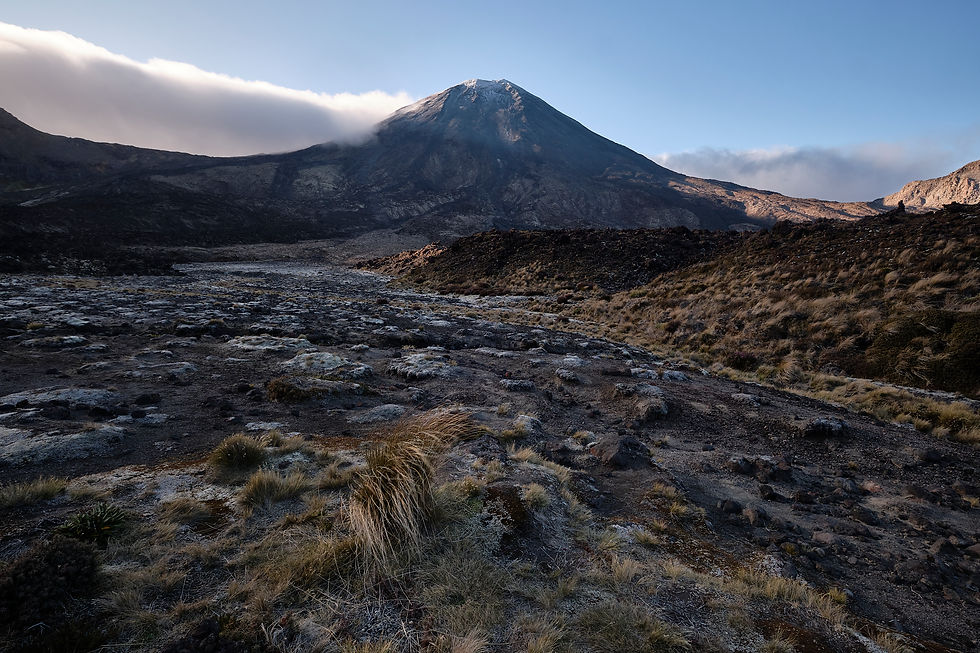
The Tongariro Alpine Crossing climbs between the volcanoes, Mount Ngāuruhoe and Mount Tongariro, crossing the volcanic terrain, in the central area of New Zealand’s North Island, 20 km southwest of Lake Taupō. Both mountains are active volcanoes, the most recent eruptions being in 1975 for Ngāuruhoe and 2012 for Tongariro. The area is within the Tongariro National Park which was put on the UNESCO World Heritage list in 1993, achieving this status both for its natural environment and for its cultural significance. The mountains at the heart of the Tongariro National Park have cultural and spiritual significance to the Maori, Ngāti Tuwharetoa people, and symbolise the spiritual links between this community and their environment.
The Maori saw the heart of the mountainous area as sacrosanct. The Treaty of Waitangi of 1840 granted chieftain rights over the Tongariro to the Maori, but this treaty was largely ignored by the British Crown and the Maori were for the most part alienated from the management of this significant natural resource*. In 1887 Chief Horonuku te Heuheu Tukino IV, and the Ngāti Tuwharetoa people, gifted the three volcanic peaks (the third being Mt. Ruapehu) to all the people of Aotearoa (New Zealand). The intention was to enter into a partnership with the Crown, to ensure the continued protection of Tongariro, and also to prevent the land ever being sold privately. In 1894, the Tongariro National Park was established, the first for Aotearoa/ New Zealand, and fourth in the world. The size of the park of the sacred mountain peaks increased significantly from the original 2,640 hectare into a 25,000 hectare land block vested solely in the Crown.
The treaty of 1840 is considered a living document, and its principles continue to guide the relationship between the Crown and Maori in matters related to land, resources, and cultural heritage. The recognition of Maori rights and the involvement of iwi in land management and decision-making are essential in honouring the cultural history and relevance of Tongariro's terrain to the Maori people.There continues to be discussion about the Maori concerns for, and interests in the area and their wish to attain redress for what they see as longstanding breaking of treaties and agreements, over their territorial and legal rights. Positive steps have already been made, and many of these issues have been and are currently being debated in the New Zealand parliament.
Today, the Maori tribes (iwi) in the Tongariro region, such as Ngati Tuwharetoa, continue to have a strong cultural and spiritual connection to the land. They have stewardship responsibilities and play an active role in the management of Tongariro National Park. The iwi have entered into various agreements and partnerships with the Department of Conservation and other stakeholders to protect and preserve the cultural and natural values of the area. Their continued existence in this environment ensures the cultural, spiritual and environmental values are protected and shared with all those that encounter this dynamic landscape.
The park has active volcanoes, a diverse range of ecosystems and some remarkable landscapes , each deeply enriched with stories and myths of significance to the Maori. It can be prone to occasional steam eruptions, volcanic gas emissions, earthquakes, landslides, uplift, subsidence, changes to hot springs, and/or lahars (mudflows) when it is clearly unsafe to attempt the trek. Clouds of ash erupt from Ngāuruhoe on average every six years, but lava eruptions are less common. During the last and most violent eruption, in 1975, gases streamed from the crater for several hours, producing a turbulent plume of ash that towered up to 13 kilometres above the crater, and a 3,000-tonne block of lava was thrown 100 metres out of the crater. There are several visible steam vents at the Te Maari craters from the eruptions from the Upper Te Maari Craters on Tongariro in August and November 2012.
What can be seen at all times outside of these spectacular disturbances are steaming vents, hot springs, old lava flows, beautiful water filled explosion craters and stunning landscape. The photographs in this book are an attempt to recognise and demonstrate the significance of the area by acknowledgment of the spectacular nature of the topography and its formation, during a walk through this rugged landscape. The images are intended to act as a visual narrative of the experience of traversing this stark and spectacular volcanic terrain.
*There were two versions of the 1840 Treaty, one in English and one in Maori. There were significant differences in translation so much so that there has been dispute to this day about what much of this agreement actually meant.
(May 2025: The recently elected government (Oct 2023) in New Zealand is seen as attempting to row back on agreements made as recently as the end of the 20th century.)
Sources of information: Eileen McSaveney, Carol Stewart and Graham Leonard, 'Historic volcanic activity - Tongariro and Ngāuruhoe', Te Ara -
the Encyclopedia of New Zealand,
http://www.TeAra.govt.nz/en/historic-volcanic-activity/page-3 (accessed 9 July 2023)
"Department of Conservation (NZ)". www.doc.govt.nz